Reason #6 for moving to the Bay Area

10 06 2015

Moving to the Bay Area took a big leap of faith on my part. I left the Northeast, the part of the country I was most familiar with before this. Even though I was born in South Florida and technically I have only spent less than one third of my life actually physically in the United States, it was the Northeast with which I most closely identified. My family held season tickets for the Philadelphia Flyers (1985-87), I grew up saying “wooder” (water) and anything west of Pittsburgh and south of Washington DC was a great big black hole for me.

But my husband, a citizen of a country that is not the United States, who fell in love with the West during a previous life as an adventure guide for European tourists, opened my eyes to the wonder, beauty and possibility of this part of the country almost exactly eight years ago this week. It was our first big trip as a couple, a little more than a year after we had met…. a road-trip through the southwest, starting in Los Angeles, snaking through all of the highlights like Grand Canyon, Bryce, Zion, Las Vegas, Death Valley, and ending in the Bay Area. That’s when we started preliminary discussions on the possibility of moving here for good, at some undetermined moment in the future.

So now we are here, in our house and getting to know our new community. To help assimilate and acclimatize, I am compiling a list of reasons it’s nice to live here. I’m only up to about 6 so far (we have only been here 2 weeks), but yesterday added a pretty significant one: Day-trip to Yosemite National Park.

Half Dome.

Half Dome.

Okay, so it is kind of far for a day trip from the San Francisco Bay Area (about 170 miles / 270 kilometers each way), but it’s possible and that’s the main thing. R. and I packed some sandwiches, fruit and water and headed into the hills. It was the hottest day of the year so far (103 degrees F / 39 degrees C) but we still managed two hikes that included some significant elevation changes.

Yosemite Falls.

Yosemite Falls.

Yosemite remains in my “Top five places to see in the United States” and I continue to be stunned by its breathtaking beauty, even after visiting it several times in the past couple of years. The views just never get old.

IMG_4377_1

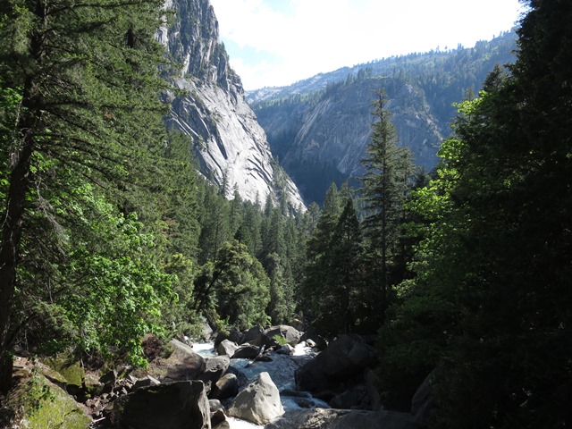
From the bridge below Vernal Falls.

Vernal Falls.

So yes, I think I’m acclimatizing well to my new surroundings out here on the left coast. It’s not a black hole after all.


From sea to shining sea

1 06 2015

We made it.

Our coast-to-coast road trip, planned by master travel planner R. (his website will be ready soon and please do think about using his expert services the next time you are planning a US road-trip…), took us through 18 states and one Canadian province, on a not-so-direct route from the Fort Point Channel in Boston to the San Francisco Bay, from lobster-crazed New England to drought-parched California, from the worst winter in recorded history to a climate that we think we just might enjoy more.

It was an epic journey, and not only because we ran out of gas on the New York Thruway in the middle of the night. We saw so much. And we saw so much beauty, and so many contrasts and contradictions. We experienced kindness and shared meals with great old friends. We drove 90 miles per hour on the Interstate in some places, and stopped for something unique and singular, not found anywhere else, in others. We learned about this country in a way that is only possible when you travel across it on the ground rather than 33,000 feet up in the air.

Where we started: Downtown Boston.

Where we started: Downtown Boston.

Where we finish: San Francisco.

Where we finish: San Francisco.

Now it’s time to get our act together to make ourselves comfortable in our new home (photos to come of course). But before we move on to the mundane details of setting up house in the suburbs (and looking for a job… that’s kind of not mundane…) here is our road-trip by the numbers:

Miles/kilometers driven: 5,435/8,750

Gallons/liters of gas used: 211/836

National Parks visited: 6

Speeding tickets received: 0

Times we got stuck and had to call AAA: 1

Days it rained at least once: 16

Days we drove into severe thunderstorms/hail/snow: 4/2/2

Breakfast bagels: 8

Beef dinners (burgers, steaks, sandwiches): 8

Meals at Denny’s: 3

Hotel hot tubs used: 4

OK, we are off to buy a refrigerator, a washer and dryer, and a grill for our back terrace. I can smell the barbecue already!


The loneliest road

29 05 2015

There are a lot of lonely roads out there criss-crossing the United States. But the LONELIEST road in all of America, as noted in our Rand Mcnally Atlas, is Route 50 which goes east-west across much of Utah and Nevada.

There's even a sign that says so.

There’s even a sign that says so.

What is there to say about this particular route except that… it really is lonely out there. We spent maybe 8 hours on this road in total driving west, and saw just a handful of other living souls amongst the herds of free-range cattle that inhabit this part of the world (I call them “lucky cows”). There are old mining towns along the way, not quite abandoned, but also not quite alive.

Not much there.

Not much there.

Ely, in central Nevada, is the biggest town for miles, a three-hour drive to the next municipality of any significance. It’s hey-day ended in the 1970’s, it seems, when Interstate 80 was built about 140 miles / 310 km to the north, and passed it by. It’s a place you drive through and remark, “Gee, looks like this is a place where time really has stood still,” and wonder why one would ever consider spending more than an overnight here. It has a bunch of run-down motels and a few casinos where you can play blackjack for $3 a hand. (And we did. It was entertaining. But the house still won.)

Then about 150 miles later you run across the community of Eureka, Nevada, which (unbelievably) boasts a completely renovated Opera House, apparently with an arts community to use it.

Who would have thought?

Who would have thought?

And just FYI, if you are thinking of retracing our steps on this particular section of our cross-country journey, travel on The Loneliest Road in America also requires some careful advance planning.

Meaning: Gas, food, toilets. You have been warned.

Meaning: Gas, food, toilets.

Don’t say you haven’t been warned.


No words, just sheer beauty

26 05 2015

Words cannot adequately describe the stunning beauty of Canyonlands and Arches National Parks near Moab, Utah. I was there for the first time the other day, and I think I must rank them up there with Grand and Bryce Canyons as some of the most magnificent, breathtaking places on earth. So I will spare you the words today, and just offer up a bunch of pictures. (If you click on each of the pictures, a high-resolution file will open up in a different window.)

IMG_4203_1

IMG_4189_1


The biggest rip off in America

24 05 2015


Because there has to be one, right? And I found it.


Step right up to the world famous four corners.

Step right up to the world famous Four Corners.

Four Corners is an arbitrary point on planet earth where four U.S. states meet – the only spot like this in the lower 48! – because surveyors in the late 19th and early 20th centuries decided it should be so. And thus created the crappiest, biggest rip off imaginable. For the geographically challenged: Utah, Colorado, New Mexico and Arizona (clockwise, starting in the upper left-hand quadrant) are the fantastic four we are talking about here.

The actual point of interest, called, appropriately, Four Corners, is where these four states meet. It is situated on a piece of land belonging to two native American tribes, the Ute in the northeast, and the Navajo everywhere else. The drive to the “national monument” is up a dirt road on Navajo land in New Mexico. The entrance fee is $5 per person. There is no printed information or map (as one would usually receive when, say, entering a National Park run by the Department of the Interior) but rather a tourist brochure dated “Summer 2012.”

Once inside the fenced-in enclosure (be sure you don’t throw out an axle on the pot-holed muddy driveway) this here is what people have come all this way to see.

Yep, that's it.

Yep, that’s it.

Around this arbitrary point on the ground are amphetheater-like rows of benches and low balconies, one in each of the four states, so that tourists can have themselves photographed with whichever of the four state names and state seals they wish – or all of them! (And sit as they watch others be photographed.) Beyond the benches, on all four sides, are stalls with hawkers hawking original Native American arts and crafts (Made in China?) and food that would give you (and your cardiologist) a massive heart attack. I did not visit the outhouses so I can’t report on their ambiance and cleanliness or lack thereof.

It’s a place where someone a long time ago said: “If you build it, they will come… and they will even pay good money for the privilege.” And they actually, do come in droves for the opportunity to pay $5 a head in order to stand in line to get themselves photographed with their two feet in four states simultaneously. Or doing a pushup, with each limb in a different state.

How… um… exciting.